Upon entering Bolivia I traveled to the town of Tupiza.


The Salar de Uyuni is the largest salt flat in the world at over 4,000 square miles (10,000 square kilometers). The Salar was formed as a result of transformations between several prehistoric lakes. It is covered by a few meters of a salt crust. The crust serves as a source of salt and covers a pool of brine, which is exceptionally rich in lithium. The Salar is both a natural resource and wonder.

Day 1, In a Toyota Land Cruiser we headed down a dirt road.

Our driver

Our cook

Isaline from Belgium. She enjoys being in photos.

Mark from Holland. He loves taking photos.

Raphaelle from France. She hates being in photos.

We'll see what happens.

From the lowlands we headed toward the altiplano (highlands)

We passed a number of ranges and rock formations

Up to 12.000+ feet (3,600+ meters)

It was an arid landscape.

After driving all morning we took a break at this shepherd hut to eat lunch.

I took a little walk.

I found these... they look like coffee beans.

But they are actually llama poop.

Mark made an effort to fit through the little doorway of the shepherd hut.

We had a little maintenance issue with our truck. Our driver had to change the rear tire. There was not much tread on the old tire... and the new tire did not look much better.

We rode on and came across this little town.

There was an old church building made out of adobe.

And a military fort made out of adobe.

The soldiers were actually up on this nearby hill overlooking the town. They were just chillin' and singing.

I caught a glimpse of life in this small town.... a woman washing the laundry as her child sits in the shade.

It seems that Evo Morales, the current president, is popular in this town. They want four more years.

Raphaelle got into a conversation with this local lady. The lady said that not many tourist passed by this town. Raphaelle tried to explain where we were headed.

I can not remember the last time I actually used a phone in a phone booth. I had to try to place a call. Unfortunately, I could not get the phone to work.

We were headed toward these lagunas (lakes).

And these snow covered peaks.

The first day was a long day of traveling. We left Tupiza at 8 in the morning and arrived at our destination after 8 in the evening.

Our accommodation was a pretty basic hostal... no electricity, no heat and sporadic water.

The rooms were pretty simple, but luckily the beds had plenty of covers. The temperature can get down to 20 degrees below 0 in the salar. I slept in my sleeping bag with extra blankets on top.

Day2, In the morning we packed up our gear and prepared to drive off.

But our truck would not start. The driver tried to jump start the battery, but eventually he had to switch out the battery.

We had some time to burn... so we just chilled.

It was cold outside, but slightly warmer inside the truck

We took a little walk and came across this frozen water

And this frozen lake

Isaline going on a walk

At Laguna Morejon there were deposits of borax.

It is the same substance that is used in laundry detergent.

At this laguna, the group tried their luck at walking on water.

We road on down a dirt road.

We came across this laguna with pink flamingos.

Raphaelle was stoked.

Laguna Celeste

The roads were often not really roads, but more like tracks in the sand.

Laguna Verde and Vulcan Lincancabur.

Isaline on a walk.

Raphaelle on a walk.

There was lots of space to just walk.

A bad hair day for me.

More borax

We came across these aguas termales (geysers).

Hot stuff

But our guide did not even mind if we walked among the geysers.

Pretty strange sensation to get so close to the geysers and hot steam.

Luckily I survived and received a free steam facial at the same time.

We rode on and came across this hot steam bath

We did not hesitate to take advantage of the hot water. We had not bathed the night before.

Hmmm...come to think of it... I'm not really sure when was the last time I bathed .

We rode on.

We approached the Laguna Colorado

A reddish colored lake

With flamingos

There were all kinds of interesting shapes in the salar.

Textures

Formations

Lines

Colors

This rock formation is known as the Arbol de Piedra (Tree of Stone).

We took some time to explore around the area.

Isaline was on top of the world... or at least this rock

I was trying to look for new perspectives

The days were long... and so were our shadows.

Day 3, Another laguna

More flamingos

Andino flamingos

This strange green fungus only grows 1 square inch a year.

It may take decades to cover a rock

Interesting point

This little guy looks like a rabbit.

But look at it closely and it has a long tale... it is a viscacha.

Sometimes it is good to just ponder life.

And sometimes you just have to go with the flow

I'm trying to not let the weight of the world get me down.

Apacheta

Our cook decided to go on her own walk.

And gathered some herbs to make us tea.

We came across this town which had burial mounds.

Inside were human remains.

Skulls and whole bodies. Kind of gave me the creeps.

We finally reached the salt flat by the late afternoon. We went on a little walk.

The low sun on the horizon combined with the flat terrain created long shadows.

The salt flat... indeed... lots of salt... and very flat.

We stood in awe.

We had traveled three days to reach the salt flats... tomorrow we would have a closer view.

We slept in a hostal made entirely of salt... salt bricks.

Salt tables and chairs

Salt beds. OK, you get the idea.
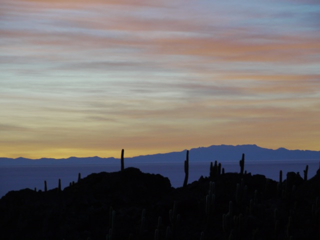
Day 4, we woke early at 5 am to try to get a glance at the sunrise over the Isla de Pescado.

We almost missed it.

But we caught the sun rising over the horizon. It was difficult during this trip to get Raphaelle to pose and smile for the camera, but the sunrise and scenery brought a smile to her face... so I snapped this image. I think that she will thank me one day.

Some interesting shadows.

I took a walk on the salt flat.

I could see for miles and miles and miles.

Lots of salt

I had to taste it to see if it was for real... it was.


OK, time for some fun with the camera.

With the right angle and perspective

One can make magic

Or just play around

No fancy camera angles here... just a good composition. It is not easy getting a llama to pose like this for a photo. I had to work for this image.

How about two llamas. I thought this image summed up nicely the Salar de Uyuni.

Some parts of the salar are covered in water.

Which gave me time to pause for reflection.

People do make use of all this salt.

They pile it up, harvest it, sell it and make a living.

But travelers just make goofy photos with it.

Looking back or looking forward... it's all the same in the Salar de Uyuni.


Troy,
ReplyDeleteWhat camera and lens do you use the most?
- wei
Wei, tough question. For my Panasonic GH2 I only have one lens...a 18-140 zoom. But I'm also carrying a gopro wide angle camera, iPhone and a samsung point and shoot. Most of these photos were shot with my Panasonic GH2.
ReplyDelete